Click on the thumbnail to view the full size photograph. Use your
browser's back button to return here.
 On Silver Lake
Silver Lake, a private lake located in Rehoboth Beach, DE., is home to a
number of waterfowl. The day before this photograph was taken, we drove
through a howling blizzard from Baltimore to Rehoboth Beach. These mostly
Canada Geese have to negotiate snow and ice to reach the open water on the
lake.
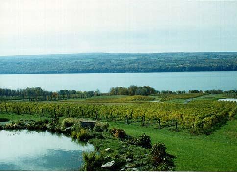
 Vineyard in the Finger Lakes
Located in the middle of New York State, the Finger Lakes are long, narrow
and cut deeply into the Appalachian Plateau. Because they are so deep, they
tend to have a mitigating effect on the weather. This helps to make hillsides
around them and plateaus between them good for vineyards. The large New
York State winery industry is located primarily here, from the well-known
Taylor and Great Western brands to smaller operations such as Wagner and
Bully Hill. The lake in this photo is, I believe, Seneca Lake.
 Fall In The Finger Lakes
This is another view, from the other side, of Seneca Lake and the surrounding
plateau.
 Montezuma NWR
Driving along the northern route from Cooperstown, NY, to the Finger Lakes,
we discovered a beautiful National Wildlife Refuge, Montezuma NWR. You can
only drive along certain roads throughout the impoundments and are not even
supposed to get out of your car, though I did cheat a little to get this
photograph. Still, my feet never left the road!
 Harbour Town
This is a view of the lighthouse and harbor in Harbour Town on Hilton Head
Island, SC.
 Skyland
In the second week of October, we spent a weekend on Skyline Drive, in the Shenendoah National Park. The park sits astride a section of the Blue Ridge Mountains, an easter rampart of the Appalachians. To the east are the rolling lands of the area called the Piedmont and to the west are the Appalachian mountains and valleys. When the park was created, in 1926, nearly all of the land had been cleared for farming and wildlife was either rare or absent. Now, more than 95% of the park is reforested and deer, bear, bobcat, turkey, smaller animals and numerous bird species are abundant and often seen in the park. Unlike the mountains of the west, these are very old mountains, some more than 1 billion years in age. Skyline Drive runs the length of the park and connects with the Blue Ridge Parkway to the south. It runs approximately parallel to a portion of the Appalachian Trail, which criss-crosses it a number of times. This photograph was taken from the porch of our room at Skyland, one of only three lodging facilities on the drive. Skyland, at an elevation of 3,680 feet, is the highest point on the drive, though Hawksbill Mountain, at 4,051 feet is the highest point in the park.
 Range View Overlook - el. 2810'
I will try to present these in as close to "north-to-south" as I can and will include elevations where possible. Sometimes, no words are needed. The views speak for themselves. These are the Blue Ridge Mountains.
 Range View Overlook - el. 2810'
 Mount Marshall Overlook - el. 2850'
This is the western-most edge of the Piedmont.
 Mount Marshall Overlook - el. 2850'
The arrow points out a portion of Skyline Drive ahead.
 Thornton Hollow Overlook - el. 2450'
 Tunnel Parking Overlook - el. 2510'
A short distance south of here is a tunnel, Marys Rock Tunnel, built in 1932, which goes through 600 feet of rock.
 Hazel Mountain Overlook - el 2770'
Again, this view to the east shows the rolling Piedmont of Virginia.
 The Drive
This is a view of the Drive itself as seen from the Hazel Mountain Overlook. This is the road we were driving on.


 Vineyard in the Finger Lakes
  Fall In The Finger Lakes
 Montezuma NWR
 Harbour Town
  Skyland
 Range View Overlook - el. 2810'
 Range View Overlook - el. 2810'
 Mount Marshall Overlook - el. 2850'
 Mount Marshall Overlook - el. 2850'
 Thornton Hollow Overlook - el. 2450'
 Tunnel Parking Overlook - el. 2510'
 Hazel Mountain Overlook - el 2770'
 The Drive
 Return to index
 Go to Patterns And Perspectives